
Active Microwave Derived Surface Melt
Active Microwave Derived Surface Melt
The time-varying areal extent and duration of surface melt on ice sheets serve as key indicators of climate change in polar regions. Within the Polar+ projects 4DGreenland and 4DAntarctica, a novel algorithm to produce time-series of surface melt extent and melt phases (dry, wet refreezing) was developed and applied to assess the dynamics of seasonal melt and refreeze on ice sheets. Based on continuous C-band active microwave satellite data analysis, preliminary results have demonstrated the suitability of the METOP ASCAT scatterometer and Sentinel-1 SAR missions for consistently monitoring snowmelt on a continental scale.
In the 5DAIS project we propose to develop a method for inverting the backscatter signal to derive the thickness of the refrozen layer, based on estimates of the volume scattering properties of dry snow/firn derived from the backscatter signal during the winter season.
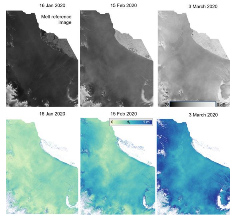
(Upper row) Sentinel-1 C-Band HH backscatter maps; and (lower row) estimated depth of refrozen surface layer on top of wet snow for 16 Jan 2020 (maximum melt), 15 Feb 2020, and 3 Mar 2020.
Summary of the active microwave surface melt datasets planned within 5DAIS:
- Further advancements of the ASCAT melt phase products produced within 4DGreenland and 4DAntarctica.
- investigate also the synergy of C-band and L-Band SAR, which has a larger penetration depth, for calculating the refreezing depth (e.g. using Sentinel-1, SAOCOM and NISAR).
- Explore the capabilities of P-Band acquired by ESA Earth Explorer satellite BIOMASS (scheduled for launch in September 2024) for detecting and monitoring subsurface liquid water presence.